
“Deserted tropical islands, clear blue seas, Kuna fishermen bringing fruit, vegetables and fresh lobsters in their small canoe dugouts. How else can you describe it? It must be the closest we’ve been to paradise since French Polynesia and the south pacific. But the trade winds blow through the San Blas with relentless regularity, a foretell of what we had to come when we left the sanctuary of the islands – to hit seas we never expected.”
Marie
San Blas Islands – San Blas to Cartagena, Colombia
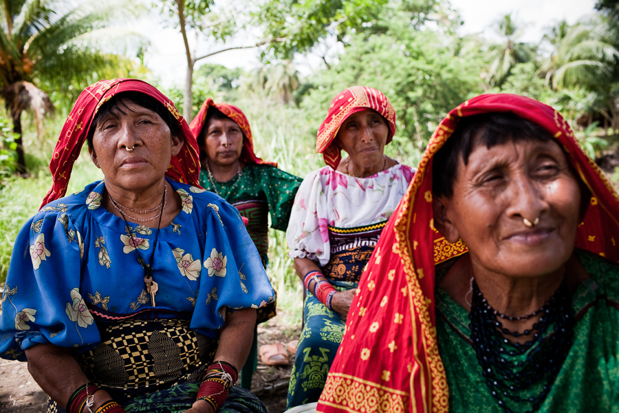
The Kuna indigenous people have long inhabited the San Blas. They’ve been there forever, it’s their unique island living – there’s nowhere like the San Blas on the whole planet. The Kuna are autonomous from Panama, each small island has its own government, its own laws with a distinct way of life. Only Kuna people can live in the San Blas – there’s no high-rise tourism, no all-inclusive resorts and no wealth-driven properties taking over the island shorelines. It really is paradise, seriously – it is paradise.
Are the San Blas under threat? Well, yes, the oceans have to rise only fractions of metres and they’ll be gone. A more immediate threat are the multitude of vacation property developers itching to get their hands on this hundred-mile stretch of pure unadulterated paradise, unimaginable sums in bribes have no doubt been offered by get-rich-quick magnates to those who say they are able to fix it – but the small island governments in their parliament longhouses say no, they don’t need what we need, they’re happy to live like they have for the last few hundred years. They’re a small diminutive race, they are large and tall in their resolve – but for how long can this last?
We rounded Punta San Blas making for the Canal De San Blas, a precarious route through the reefs and shallows to the Kuna government island of Porvenir with its three picturesque buildings and airstrip. These looked official buildings – we realised that we had already formally checked out of Panama, so we veered away to anchor behind the waterborne settlement of Wichubuala. Here, a single man and woman in their dugout guided us to the only spit of sand where we could safely drop anchor in a reasonable depth – would we drift onto the reef only a few metres away, Marie asked. No, the man said – his woman enquired if we’d like to buy her Kuna handicraft. We looked, the workmanship was incredible.
We intended to anchor behind Wichubuala overnight only. We stayed four days. The Kuna were friendly, come ashore they said, look around our government building, buy some handicraft, maybe some eggs. We did both. They desired fresh water so we filled water containers from our watermaker, we make freshwater onboard from seawater. We had to leave – Henry’s girlfriend Emma would soon arrive from Panama City. There was only one way into the San Blas for her overland, a four-hour dirt track ride to Carti around ten miles south – a fast downwind sail from Wichubuala to then anchor behind the mangroves of Punta Redonda.

Leaving Wichubuala was easy enough, we sailed downwind out of the anchorage in a fifteen to twenty knot breeze. Simple, straightforward, the sort of fast easy sailing we relish, there’s no big sea in the San Blas because the outer reefs and islands break up the surf and ocean swell. So you get the wind to sail fast on flat seas – perfect. Except that, unbelievably, after less than a mile, our headsail tore itself into shreds. We quickly furled it then let out our main to keep us fast on course, we got ourselves into the shelter of Punta Redonda and then dropped anchor. There we unfurled the headsail, all the stitching was rotten, another result of being abandoned for eighteen months in sun-parched Vista Mar – we never had time to store the sails away when we got evacuated from Panama at the beginning of the pandemic. Marie and I worked to drop the sail while Henry took the dinghy to find Emma.
Of course, I was worried. Having crewed on various yachts over the years, crew dynamics in the small confines of a sailing yacht can often be a nightmare – tales abound in marinas and harbours when it comes to how well or not crews have gotten on together, there are plenty of horror stories – lots. The skippers task in managing his or her crew can be extremely hard work – and sometimes its the skipper who is the one who is at fault. Knowing this, and with it being Henry’s mother meeting her son’s new girlfriend for the first time, with Henry & Emma sleeping in the same cabin to boot – there was no way, in my mind, that this would go well. And poor Emma? Meeting her English boyfriend’s mother and step-father on their boat? Now, you tell me, how could this go without a hitch? In no uncertain terms Marie wished to make the greatest first impression she could – so when our torn headsail dropped to the deck, caught by a sudden strong breeze, Marie jumped spreadeagled across the sail to hold it down, her dress above her waist just when Henry appeared from around the mangroves in the dinghy with Emma… you couldn’t make this up. There followed a frantic thirty seconds that did not work, when Marie tried desperately to make out a normal situation – pulling down her dress while Henry manoeuvred the dinghy to tie onto our stern. In these embarrassing situations there’s nowhere to hide except in the back of your mind, when you try to convince yourself against the odds that everything looks fine. I was horrified.
It’s a testament to both Marie and Emma that both took this first meeting in their strides. Emma stepped onboard, English breakfast tea was served and the best of my jokes to save the day were ignored. Everything seemed okay. But clearly we had a problem with our sail, it is the number one jib that drives the boat along with our main – we had a larger genoa spare buried in our sail locker which we could easily hank on but I felt that, with our plan to head directly into the winds by heading east, our genoa was too big, it might need to be continually reefed. Sänna is a cutter-rigged sloop, we still had our staysail that is hanked between our mainsail and headsail, our staysail is primarily a storm sail for big winds, a good sail to use whenever we are heading into wind – we had last used it in the infamous papagayo winds around Nicaragua and Costa Rica when we had sailed in gusting fifty knot headwinds – we’d had an excellent sail until the papagayos finally blew themselves out. We decided not to rig our spare genoa sail, our staysail and mainsail combination should easily be sufficient to get us through the gusty San Blas islands and across to Cartagena in Colombia.
After breakfast and the obligatory safety briefing for Emma we pulled up our anchor, I’d planned a complex route through the myriad of San Blas reefs of around fifteen miles or so to Nabadup, an Island that included a number of sheltered anchorages that promised good snorkelling. We had been warned repeatedly that charts were not accurate in the San Blas but so far our navionics charts were proving okay. Not all underwater reefs were properly marked but the low lying islands and spits were clearly visible – by taking visual compass bearings on these island points I could work out the average discrepancy to the charts, everything then seemed to fall into place. Having already spent a good deal of time sailing Sänna in the extensive reefs systems of the Red Sea and the atolls of the south pacific, having also sailed the great barrier reef when we had taken Sänna from Darwin to Brisbane, we were well used to coral reef sailing. The best method is to sail in morning to early afternoon sunlight, it is then easy enough to spot the reefs just by the change in colour of the seawater – the key is to use your crew as good lookouts. Then there’s also the vital use of our depth sounder, by keeping a keen eye on changing depth contours it is relatively easy to position yourself on electronic or paper charts even if locations don’t exactly correspond. If in doubt turn to deeper water. There is no prime requisite for what’s called OpenCPN, a laptop based electronic charting system that can use google earth overlays that show actual reef positions from satellite photo images – useful but not vital. Our navionics electronic charts were fine, we had the excellent Bauhaus cruising guide for Panama, once I had a feel of where the reefs were in relation to the charts we never had a problem in the San Blas. I for one would never use a laptop for navigation, up-to-date tablets are fine but, other than cost outlays, nothing compares with purpose built MFD’s (multifunctional display plotters) which are purposely manufactured to operate in a marine environment – most laptops are not. In any event, every professional mariner carries backup paper charts on their vessel – they may not be used much but passage planning should always include the use of traditional charts. It’s SAFETY at all times.
Nabadup is a beautiful anchorage – we anchored in ten metres around four boat lengths from the island shore. The crew dynamics were proving okay – in fact, they were uncommonly fine considering the intensity of our living environment. Emma fitted in perfectly, the potential flashpoint relationship between a mother and her son’s girlfriend never reared its head, they got along exceptionally well but as a father myself of three daughters I knew they were both working hard to make an impression – it was an easy atmosphere onboard, special in many ways because it contributed to our memorable time in these magnificent islands. Paradise is often a perceived concept of happiness – perhaps paradise can even reside in the dirtiest and grimiest of slums if the memories that flow from it stay with you for life. Me? from the outside I could see the relationship between Emma & Henry deepening – but how could it not in such special sun-and-sea tropical island circumstances? I kept a watchful eye on my wife, but she was fine in losing her son for the first time.
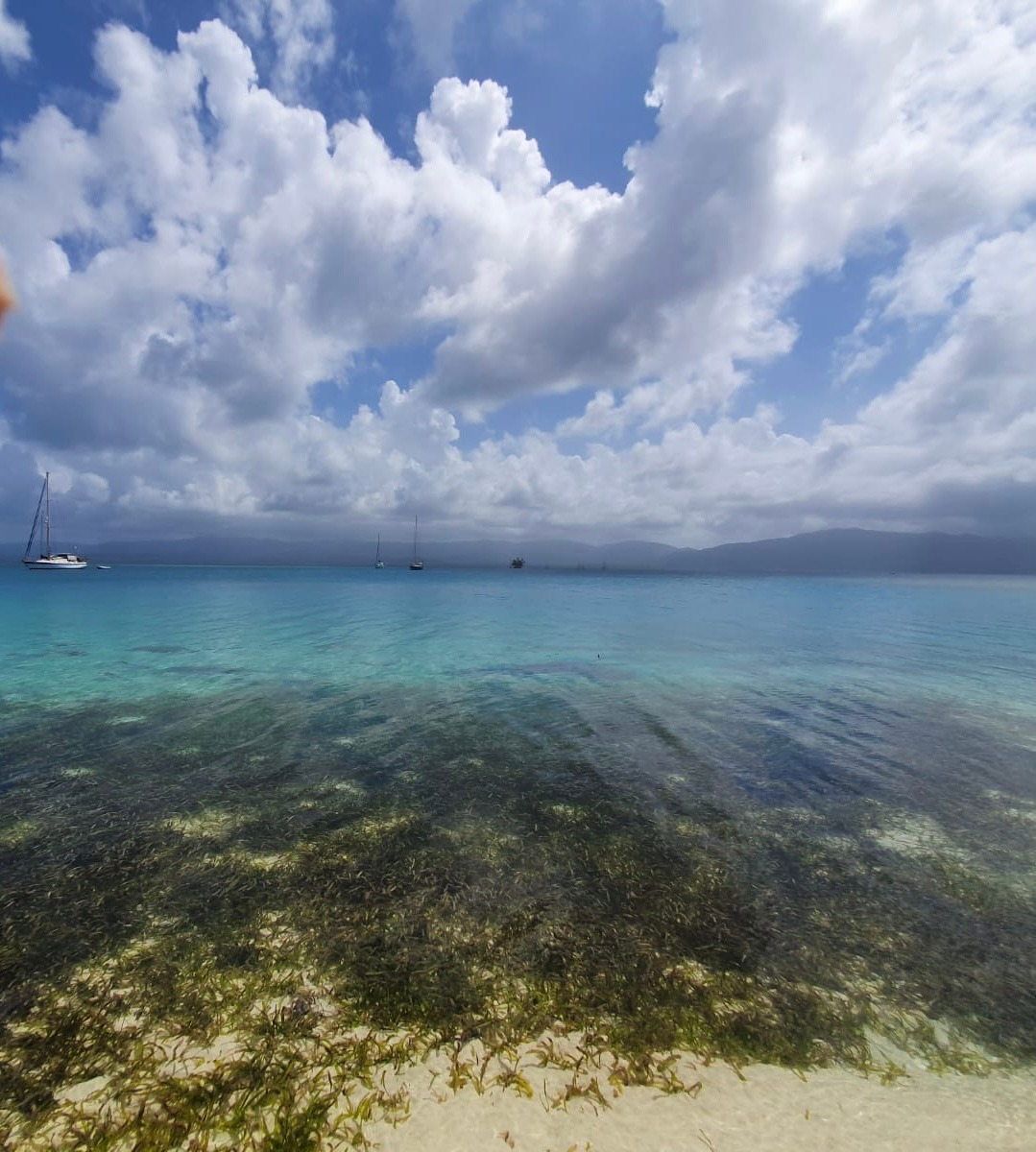
From Nabadup Island we weaved our way through countless reefs and shallows, cutting to the south of Cambombia Island before rounding northwards to attempt a tricky passage through a narrow fifty-yard gap between two reefs leading into the Canal Caobo – from our anchorage behind Nabadup I’d watched other vessels successfully navigate this precarious route with the breaking surf clearly marking the deathtrap shallows of underwater rocks and coral. Now that it was our turn, I began to have second thoughts. The shallowest part of the passage through, according to our charts, would leave only a metre of depth under our keel but the alternative was a six mile roundabout route around Gorgidup Island with its own extensive reefs. If our chart’s inaccuracies extended to the reefs ahead then we could have a problem, although, as we approached, the correct passage was clearly visible and positioned by breaking surf. A compass bearing on both confirmed the reefs were almost in the exact position shown on our electronic charts, meaning that our navionics charts were more than likely accurate for this area – if only the charted depths were correct too. They were, Marie called out the depths read by our depth sounder and Henry & Emma watched the water from our bows – they could easily see the sandy mud bottom. To test our chart’s accuracy further I veered our course from side-to-side, seeing that to both port and starboard the depths shallowed quickly – confirming that we were on course in the deepest part of the channel. We passed between the reefs with a boat length either side, the minimum depth we saw beneath our keel was just over one metre – our charts were good for this passage. Once into the Canal Caobo we could easily keep our northward course for the Islas Maqui in the northernmost Islands of Cayos Holandes – a beautiful chain of exotic islands linked by more coral reefs that stretch for a distance of over eight miles. We had dozens of calm anchorages to choose from but we decided to head for Bug Island. There were a number of vessels already anchored there with, interestingly, two large Oyster yachts that had clearly dropped out of the Oyster Rally. They were both French flagged – they’re a rebellious lot the French, these two Oysters had no doubt had enough of the Oyster razzmatazz, perhaps seeing first hand the disdain that other hardcore sailors view these types of rallies. The French are good mariners, many of the more resolute skippers we come across are French – intrepid sailing and battling against the English is unquestionably in their historic blood.
Bug Island is not the infested island that its name suggests. It’s a pristine sand-strewn shoreline flanked by continuous coral reefs that once more protect the anchorage – by now the trades were blowing at anything between fifteen to twenty five knots though the sea was flat calm. The breeze kept the temperature and humidity down to comfortable levels. Snorkelling the reefs was easy enough, Henry & Emma would take off in the dinghy for hours on end or just disappear onto the island for endless walks through the palm forests. We stayed four days, before continuing westwards under sail to the main group of island cays which we had been told would be more touristy. The Cayos Limon (Limon Cays) form the most extensive island group with an uncountable number of coral reefs – some uncharted and elusive. The anchorage names bear testament to their reputation – Barbecue Island, The Swimming Pool anchorage, Dog Island and the beguilingly named Isla Elefante, all dreamily tropical and remote. But, as we had been warned, these islands are well within water-taxi reach from Carti – daily backpacker tourists flooded the beaches and cayos, with their sometimes overpowering dance music breaking the silent tranquility. Charter boats too – lots of them.
Henry & Emma planned to leave the San Blas together, we sailed Sänna from our anchorage behind Palm Island, with its beach bar and small restaurant, back to Carti. The sea around Carti was roughing up, it would be difficult to land the dinghy at the water-taxi landings as we had planned, instead we once more dropped anchor behind Punta Redonda and managed to stop a passing water-taxi that obligingly came alongside. They both jumped aboard the panga, they were quickly gone, it seemed strange that Marie and I were a crew of two once more. The whole experience with Emma & Henry had worked well, we were both sorry to see them go. Now the two of us had an important job to complete – we needed to get Sänna out of the San Blas, out of Panama to Colombia. After all, we had officially checked out of Panama over three weeks previously…

The San Blas Islands to Colombia
Leaving the San Blas is not easy. The outer barrier reefs stretch for nearly eighty miles with few safe entrances or exits. As the chain of islands crawl away to the east the Panamanian shoreline curves distinctly southwards into the Golfo De Uraba towards the Colombian border. This area is considered dangerous, we had been warned by the port captain in Shelter Bay to stay well clear of the gulf border due to wild drug smuggling activities that’s largely overseen by paramilitary extremists. Furthermore, a new and growing problem is that of illegal refugees from Haiti in the Caribbean – they are smuggled across the Caribbean sea into Colombia near to the border with Panama, often on stolen vessels from which they begin their long trek on foot through the countries of Central America to reach the US border in Mexico. It’s a lucrative trade for these Colombian traffickers and there have been a number of attacks against foreign sailing yachts, its widely voiced that Panamanian, Colombian and Venezuelan cartels and their gangs are to blame. With this in mind we decided to go no further southeast than Green Island, partly because this point is the closest jump-off to cross the Caribbean sea to Cartagena – going further would not gain us much distance plus the prevailing trades generally curve into the Golfo De Uraba meaning that we’d have to beat our way along the Colombian coast against the wind and sea. It was the most dangerous part of the coast to boot. The question now was the wind.
From Green Island we could just about get an internet signal, which meant that we could download almost hourly wind forecast updates. A forecast is good for about the next five days but will change and update the longer it is ahead. We could see a wind window in which the winds eased from their normal fifteen to twenty-five knots and, more importantly, backed to blow more from the north. With our general course from Green Island to Cartagena being northeast to east, this would mean the wind would not be directly on our port bow – a close-haul sail is fine enough but it would be a wet passage with seas continually breaking across our bows with Sänna on a deep lean to port. A more northerly wind would blow across our beam – a fast point of sail providing we were not beam-on to breaking seas. The forecast showed we’d have favourable winds for the two-hundred odd mile passage which would take us, at the most, two days. The forecast winds for the next four days were definitely not good, twenty to thirty knots against us – we would have to so sit it out tucked comfortably and peacefully behind Green Island. Wonderful Green Island.

By now, being nearly three weeks out of Shelter Bay, we were beginning to run low on supplies. We had lots of tinned foods onboard, dried pastas, beans and stuff like that but it’s the fresh foods that make life pleasurable – eggs, salads, fruit and vegetables. We were almost out – and there are no land based shops or supermarkets in the Sand Blas, we couldn’t go ashore to buy supplies. The island communities live by subsistence living, what they have they need for themselves. When their supply boats arrive they bring essential foods only – there are few luxury goods in the San Blas, most islands have no electricity or anything like that. But the Kuna are not stupid, they see a good commercial opportunity just like anyone else – any vessel anchored around Green Island is going to be short on supplies. When the large dugout panga tied up alongside us with a banging on the hull we were amazed to see it full off everything we needed. We got eggs, potatoes, tomatoes and more – even pineapples and mangos, not the highest supermarket quality or the cheapest but wholesome and welcome nevertheless. Trading freshwater from our watermaker meant cheaper prices. Then there was the next dugout that stopped by full of fresh caught fish and lobsters…

Seven days we spent, swimming when it got hot, walking on the palm-covered island, snorkelling or lazing around doing not much. The wind forecast had shifted though we weren’t that bothered. When it came to be time to pull up our anchor we were sorry to leave – the wind patterns for the next couple of days meant it would be best to leave later in the day, meaning a two-night passage which would in theory enable us to arrive off Cartagena at first light. Of course, it never did work out like this. The first problem we faced was leaving the San Blas with our course set for Colombia, the nearest marked Concepcion ‘canal’ on the charts was around fifteen miles to the east or back to the west towards Canal Caobo – even these carried depth warnings on our charts. Studying the charts I thought we could make our way out through the reefs and shallows slightly to the northeast of Green Island – if we were careful enough it would save a long trek to the marked channels. In this I made a bad mistake. Avoiding the reefs was easy enough, the breaking seas clearly mark the position of the coral regardless of where they are marked on the chart – the shallowing depths was another matter.
The Caribbean Sea is deep. Towards the outer San Blas reefs it shallows from fifteen-hundred metres depth to under two-hundred and fifty metres then quickly to around ten metres or less. These depths are sufficient to clear our keel but the problem is the type of rough sea the shallowing depths create. The ocean itself consists of two wave forms – what’s termed as ocean swell which experienced sailors see as longer-period and non-breaking, which have been generated well beyond the immediate area – it’s the general motion of the sea governed by weather action elsewhere. Waves, which often break from their surface, are created by the local wind conditions, there is a distinct difference between the two but they can often combine to create unsavoury seas. Add in rapidly shallowing depths that drive both the ocean swell and breaking waves upwards as the seabed rises, and with coral reefs and back-swells added into the mix as well, then sea condition can quickly become treacherous. The technical term is a confused sea – but this does not adequately describe the frightening sensation of being powerless, sometimes in genuine fear of your life. Many a greybeard fisherman will regale you with tales of hundred foot waves, of towering seas that swallow boats whole – especially while you are buying his drink. Generally it is a dangerously shallowing sea that create these conditions, offshore ocean storms generate mountainous, but organised seas that can be easily dealt with by experienced mariners using long-established storm management techniques – inshore shallows with more deadly seas are something else – confused out-of-control seas can kill you.
Why I made my mistake given my experience is not easy to explain. Only when Marie stared at me as the first breaking wave crashed across our midships beam did I realise how much we were in trouble. We had no sensible reason to be here, our depth sounder was displaying alarming readings, nothing like the charted depths – two metres beneath our keel when we should have had more than thirty. If we grounded in this three-metre combination of ground swell and breaking waves then we were in unsurvivable conditions – all because I had made a stupid call to save time – perhaps I had been lulled into a sense of serenity by the docile anchorage in which we had just spent seven sun-filled days doing nothing, lounging around preening ourselves with not much to do. Even so, our experience quickly kicked in, Marie surreptitiously closed every hatch and tightened all our lines, I turned Sänna bows into the suddenly breaking waves regardless of where deeper water might be found. This was lap of the gods – shallower water we might well be in trouble, deeper we could be safe. I watched our depth sounder with eyes like a wide-eyed bug, Marie called out the depth while I fought the helm to stay in control. My sense of relief was overwhelming when the water beneath our keel increased rapidly to nearly fifteen metres and more – we had worked our way off the uncharted shoal. The sea only slightly declined in its severity but we were out of immediate danger – ahead was much deeper water and we were actually out of the San Blas. While I set ourselves back on to our course Marie appeared with two cups of hot steaming tea – every Englishman’s answer to a death defying crisis.
Things did not get much better. Once clear of the shallows we set our sails, our mainsail full out set for a beam reach. We unfurled our storm staysail because we still had no headsail hanked on to our forestay – it was ripped and torn. Right now the winds were only around ten to fifteen knots, not really enough for our staysail to do much but with the wind direction just forward of our beam we were making around four to five knots over ground. The wind was forecasted to climb to twenty to twenty-five knots overnight but would remain northerly with some west in it, more from the north than usual giving us the prospect of a decent sail through the almost moonless night. Worryingly, the sea breaking against our portside bow was still big – in the dark it would seem worse. We decided to split our overnight watch in the usual way, I would sleep the hours from around nine until two am in the morning, Marie would then take over until dawn around seven. Looking at the rough sea, I doubted that I would get much rest. The sea state was out of proportion to the wind in both direction and wind strength. No doubt these conditions were systematic of the Atlantic trades – blowing year round from the same direction all the way from the west coast of Africa.
Another Disaster
Through the night and well into the next morning the wind blew stronger. We made good progress, Sänna was sailing well – we always love the staysail heading into wind. Marie cooked up a good breakfast but the sea was steadily increasing in wave height. Worryingly, we were seeing four to six metre waves combined with the swell – not that we couldn’t deal with it, more that we had not expected a battling sea like this. But, by late afternoon, we were over one-hundred and forty miles out from the San Blas and Green Island with about sixty miles ahead of us to Cartagena, gone was our plan to arrive off the harbour entrance at first light. We were looking to slow down unless we were prepared to enter harbour in the dark, this looked an easy prospect in the main harbour but entering the tricky inner harbour to anchor might be more troublesome. We guessed by this time there might be a hint of sunrise in the sky – just enough light to get ourselves anchored around other boats. We were sailing fast and well.
Marie had just taken herself below to shower and prepare an evening meal, the sun was quite low in the sky. I thought the staysail looked weird in its shape just before it came crashing down to our foredeck. Emergency – if the sail continued its fall overboard then we were once more in big trouble, especially in these sea conditions. Once again we reacted out of shocked instinct, I clipped on my safety harness then raced forward to get the wildly flapping sail flat on the deck, I then heaved on what had gone overboard retrieving it with difficulty. Holding the sail down in the howling wind was tricky, but then I saw Marie right behind me with a handful of sail ties. We had the fallen sail under control but if we turned beam-on midships out of control in these seas then there was a distinct possibility we could be caught and rolled, both of us were exposed on the foredeck, it was not a safe place to be – with Marie lying half-naked across the sail I made my way back to Sänna’s cockpit to turn on the engine then the autopilot to steer us back on to our course. Everything went clockwork, once under control with our engine and mainsail driving us forward through the breaking sea I joined Marie on the wave-covered foredeck to tie the collapsed staysail down. Once safely back in the cockpit Marie apologised for her unwomanly posture while holding down the sail, almost naked with wind-driven spray washing over her – I replied that, in actual fact, it wasn’t an unattractive sight. We were both drenched and saturated to the skin.
The stainless-steel shackle holding the staysail up on its halyard had sheared. It had broken clean in two. Why? I don’t know why – when essential critical gear fails its often hard to fathom its cause. Surely it was not cheap manufacture, it had been supplied by the Selden dealer in Darwin, Australia where we had the staysail furling gear rigged new. Selden are the manufacturers of our mast and rigging, its reliability seemingly guaranteed by a well-known worldwide brand – but then Marie recalled that we had experienced similar problems shortly after the furling gear was first rigged, the whole furling wire had sheared from the mast when approaching Lizard Island off Queensland. I now inspected the shackle – it wasn’t the expected high quality Selden shackle made in Sweden. I saw the words that always make me shudder – ’Made in China’. But the shackle wasn’t in bad shape, there was no telltale rust or anything like that – it had completely sheared through – inferior quality steel I guess – I don’t know.
Now we had to make a choice. We could carry on just with our mainsail, right now with the engine ticking over we were still making two to three knots whereas we had been averaging between seven and eight – which was not bad in these conditions. But sailing just with our mainsail we would not have the power in our bows to punch through the rough sea, we would veer way off course each time a wave broke against our portside hull. Marie suggested that our only real option was to motor-sail which, of course, made sense. We were only sixty odd miles out, the wind was supposed to be slackening off but there were no signs of this yet, Sänna was safe enough but we agreed that we would be best to keep up our speed to get into the shelter of Cartagena port as quickly as we could. Two sails now down – we only had one sail left.
Next page – Arriving in Cartagena, Colombia, new sails, carnivals and new friends…
